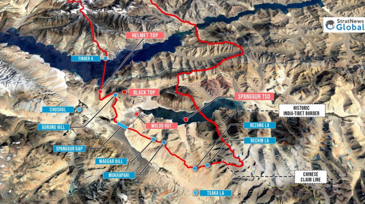
[2020.09.12] Black Top & Helmet Top 黑顶 & 头盔顶
Black Top & Helmet Top

黑头山 头盔山
Hu XiJin said: PLA didn’t lose one inch territory
Red dots are Chinese positions. Blue are Indian.
The two tops were first take by:
SFF 流亡藏人部队 – India’s “Special Frontier Force”
But later those units were destroyed by PLA, the KIA were not counted as Indian Army KIA, that’s why India didn’t publish the numbers, and no reports.


![[2021.01.09] AGAIN 我军一名士兵迷路被印度扣留 [2021.01.09] AGAIN 我军一名士兵迷路被印度扣留](https://www.zgzl2050.com/wp-content/uploads/2021/01/image-15-200x120.png)
![[MAP] 中印边境地图 + 国力 + 军力 [Galwan] [Pangong Tso] [MAP] 中印边境地图 + 国力 + 军力 [Galwan] [Pangong Tso]](https://www.zgzl2050.com/wp-content/uploads/2020/06/image-106-200x120.png)

黑顶
黑顶依然在我们控制下,就是我们的军人太苦了,目前是对峙环境恶劣程度,让山脊上的每寸国土,都成了新时代解放军边防军人的上甘岭,希望全国人民都知道,我们西部边陲的年轻子弟兵,和70年前上甘岭上的志愿军战士一样,为了祖国坚守到底[泪]🙏🙏
https://m.weibo.cn/status/4560749580782953?sourceType=weixin&from=10AA095010&wm=4260_0001
https://twitter.com/evazhengll/status/1312796501324836867
中印老黑山头盔顶对峙经过
https://twitter.com/evazhengll/status/1305081994393591808
https://twitter.com/evazhengll/status/1304810656084955142
https://twitter.com/Ataur005/status/1304834247014993922
Red is PLA
https://twitter.com/ARS19622906/status/1304744391374811137
No, the map is correct. Infact it’s the first correct map posted in all these days. Well done @nitingokhale
Now, India has not crossed LAC, as claimed by many.
India within India’s own territory as accepted by China.
But, in North Bank of Pangong Tso, China has built Military camps inside India claimed areas.
https://twitter.com/rajesha_rao/status/1304762615319601152
2020.09.12